Research Projects
Research Division
- Disaster Prevention in the Energy Supply Area Endowed Research Division (Chubu Electric Power Company)
- Disaster Preventions in the Ground and Lifelines Area: Academia-Industry Cooperative Research Division (Toho Gas Company)
- Disaster Mitigation Planning for Regional Society Endowed Research Division (OYO Corporation)
Research Project
- Study Project for Nankai Trough Broad Area Earthquake Disaster Prevention
- Tokai Disaster Mitigation Research Consortium
- Region-Based Disaster Mitigation Think-tank Based on Regional Collaboration and Information-Sharing
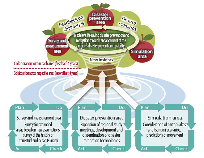
- Disaster Mitigation Renaissance through Improved Regional Capabilities
- Research and development of advanced educational materials for disaster management
Disaster Prevention in the Energy Supply Area Endowed Research Division (Chubu Electric Power Company)
● Research aims
In order to improve the ability to respond to disasters in terms of energy supply and enhance measures for rapid recovery in the case of earthquakes and other natural disasters, it is essential to conduct hazard assessments by examining historical earthquake damage, assess the earthquake resistance of energy supply facilities, and accurately understand the supply-demand balance in the case of disaster. Accordingly, this endowed research division will conduct research on the following themes with the aim of helping to enhance the region’s disaster prevention ability through the maintenance of a safe and assured energy supply.
- More accurate estimates of the scale of seismic ground motions and tsunami caused by Nankai Trough mega-earthquake
- More accurate estimates of damage at energy supply facilities in the event of Nankai Trough mega-earthquake
- Examination of preparatory measures for maintaining the function of facilities when disaster strikes, and measures for rapid recovery
Disaster Preventions in the Ground and Lifelines Area: Academia-Industry Cooperative Research Division (Toho Gas Company)
● Research aims
Lifelines such as water, gas, electricity are essential items of social infrastructure that affect all of society. Revises are underway regarding damage predictions and risk management systems in preparation of natural disasters such as earthquakes, windstorms and floods. Against this backdrop, it is critically important that we minimize damage and facilitate rapid post-disaster recovery from the perspective of maintaining social function and economy activity.
Accordingly, this research division investigates damages from natural disasters in the past, and also analyzes risks that damaged lifelines have on social structure. It conducts research on the following individual themes with the aim of realizing prevention and mitigation of disaster in urban and rural areas.
- Toughening of lifelines through assessment of the resistance of structures against great earthquakes
- Risk assessment of lifelines against water hazards such as river flood and storm surge
- Assessment of social influences exerted by reduction in everyday convenience due to damaged lifelines
Disaster Mitigation Planning for Regional Society Endowed Research Division (OYO Corporation)
● Research aims
Using sociological knowledge in addition to physical and engineering knowledge that has ever been accumulated, this research division will conduct a series of research and development activities to help facilitate regional development of disaster mitigation plans so that regional society can respond to earthquakes and complex disasters, with a focus on the Tokai area.
The division’s goal is to assess the economic damage from imminent great disaster and develop disaster mitigation plans based on predicted economic damage from the viewpoint of the region, thoroughly learning from the bitter experience of the Great East Japan Earthquake.Accordingly, this endowed research division focuses on the following areas:
- Cross-sectional studies of disaster control measures by making full use of sociological knowledge in addition to physical and engineering knowledge
- Development of a technique for estimating economic damage from disasters based on an economic equilibrium model that considers the structure of the supply chain
- Proposals for disaster mitigation measures such as effectively enhancing infrastructure, using an economic indicator
Return to the top of the page
Research Project for Compound Disaster Mitigation on the Great Earthquakes and Tsunamis around the Nankai Trough Region
With the aim of reducing damage caused by a Nankai Trough mega-earthquake and tsunami, this project will consider disaster prevention and mitigation measures and restoration and recovery plans while it will conduct investigation of great earthquake occurrence mechanism as well as clarification of subduction-zone structures and historical earthquakes and tsunamis. Nagoya University was entrusted by the Ministry of Education, Culture, Sports, Science and Technology to implement this project in fiscal 2013 in collaboration with the Japan Agency for Marine-Earth Science and Technology, the University of Tokyo, Kyoto University, Tohoku University, the National Research Institute for Earth Science and Disaster Prevention, and other organizations. Disaster Mitigation Research Center strives to enhance improvement of estimatlon accuracy of damages and develop a method to estimate damages that have been difficult to be assessed while it organizes research on region-collaborative disaster prevention. In fiscal 2017, a new attempt started to apply researched and developed measures to a specified area.
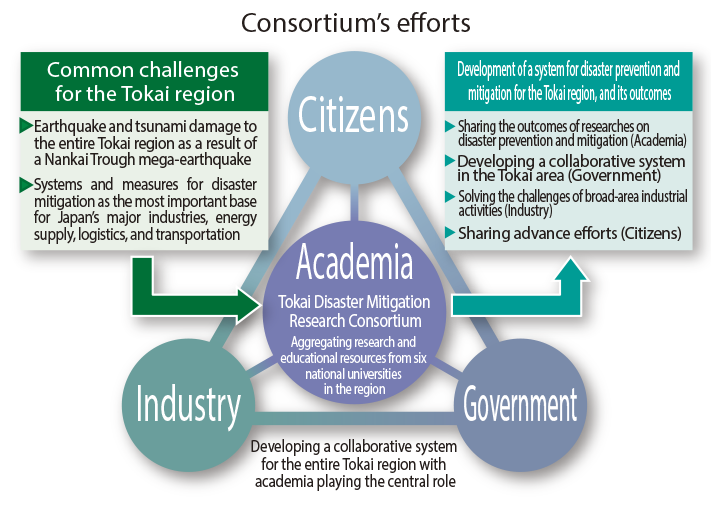
Tokai Disaster Mitigation Research Consortium
Located at the center of Japan and as the nation’s largest industrial base, the Tokai region faces the risk of a Nankai Trough mega-earthquake as well as other disasters. Therefore, developing effective strategies for disaster prevention and mitigation is a nationally important and urgent challenge. This Consortium was established with the aim of aggressively implementing research into reducing the impact of natural disasters in order to realize safe and assured regional societies. It is a collaborative effort involving six universities in the Tokai region—namely Gifu University, Shizuoka University, Nagoya University, the Nagoya Institute of Technology, Toyohashi University of Technology, and Mie University.
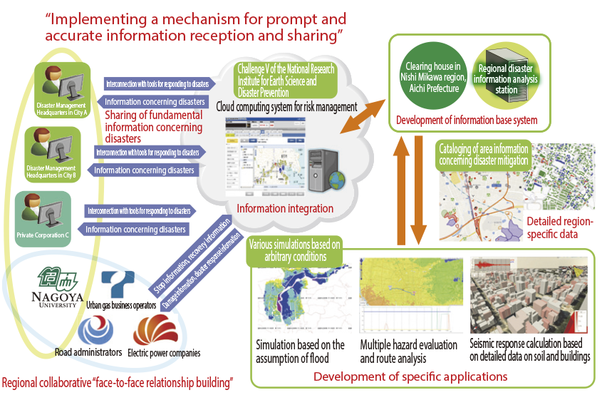
Region-based disaster mitigation think-tank based on regional collaboration and information-sharing
The cross-ministerial Strategic Innovation Promotion Program (SIP) launched by the Cabinet Office cites “Enhancement of the Resilience of Disaster Prevention and Mitigation Functions” as its R & D challenge. We are thus making efforts aiming to realize disaster information sharing and coordinated disaster response between municipalities including local companies in the region, specifying Nishi-Mikawa region, Aichi Prefecture as a model. In addition to this, serving as a core institution, we investigate the way of horizontal deployment of disaster information systems and applications developed by other adopted institutions
Disaster Mitigation Renaissance through Improved Regional Capabilities
Every year, a single municipality is chosen and designated as a model area from among municipalities in Aichi Prefecture that have populations of 100,000 or fewer (a total of five municipalities chosen in five years). All of the designated municipalities differ from one another in terms of geography, geology, past experience of natural disasters, natural disaster risk level, industrial structure, and historical background. In the model areas, documents are collected concerning regional history and geography, the population’s ability to respond to disasters, and information on disaster prevention and mitigation based on the latest scientific and technological research concerning seismic disaster prevention. Using these documents, workshops are held by municipal office staff, regional companies, and residents to pave the way toward implementation of appropriate disaster prevention and mitigation countermeasures. After the completion of this project, we will aim to apply and widely extend this study’s results to other municipalities that have geographical characteristics that are similar to those of the five model municipalities. (Business subcontracted by the Ministry of Education, Culture, Sports, Science and Technology “Project for the study on support of local disaster-damage prevention measure”)
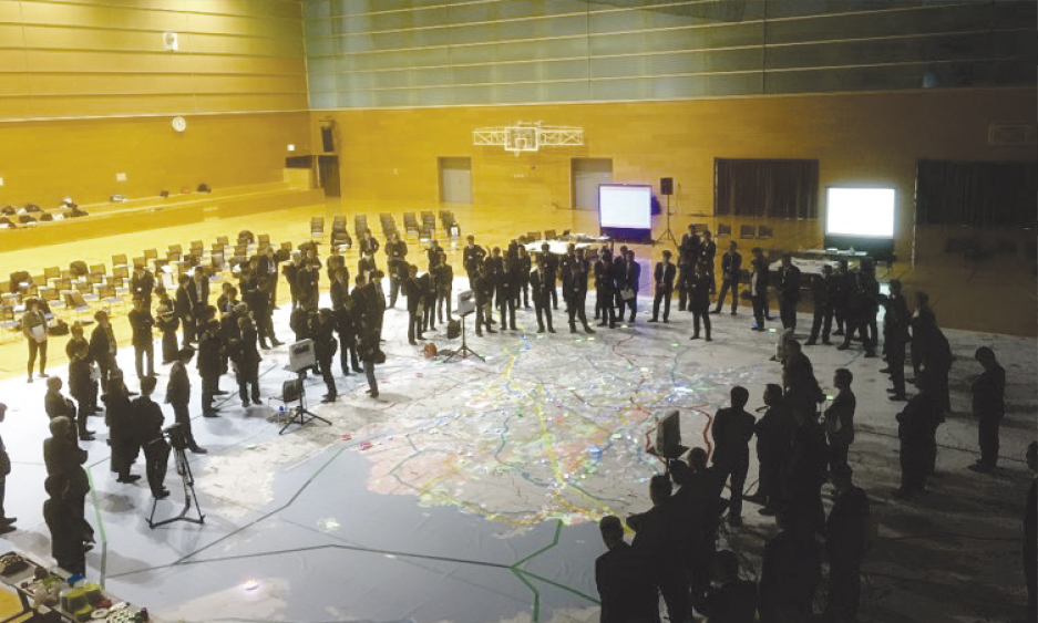
In fiscal 2017, we developed the world’ first large-scale work shop method combining the portable projection mapping system and the huge map of all of the Aichi Prefecture and the surrounding area. Many people can share the recognition of disaster situations by the system where all information including emergency routes, disaster response facilities and bases, and hazards situation is projected to overlap to basic information on the map. On January 19th, 2018, we held a workshop to discuss how to respond to the conceivable situations when the Nankai Trough mega-earthquake will occur. It was held at the Sky Hall Toyota (gymnasium) in Toyota city and more than 200 people attended including staff of Cabinet Office, Chubu Regional Development Bureau, Aichi prefecture, companies of essential utilities, and local companies in addition to chiefs of disaster prevention, road maintenance and planning sections of 9 cities and one town in Nishi-Mikawa.
Return to the top of the pageDisaster Mitigation Renaissance through Improved Regional Capabilities
 |
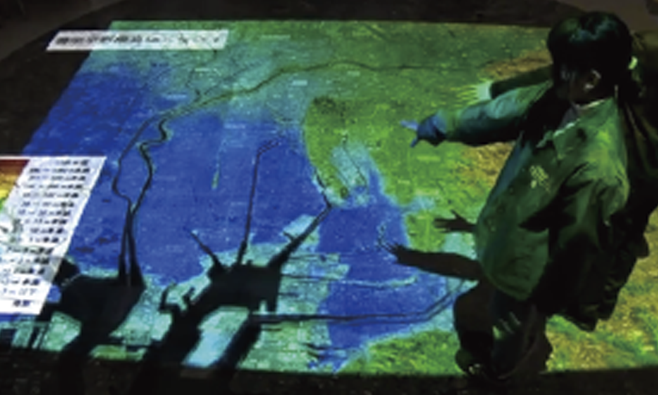 |
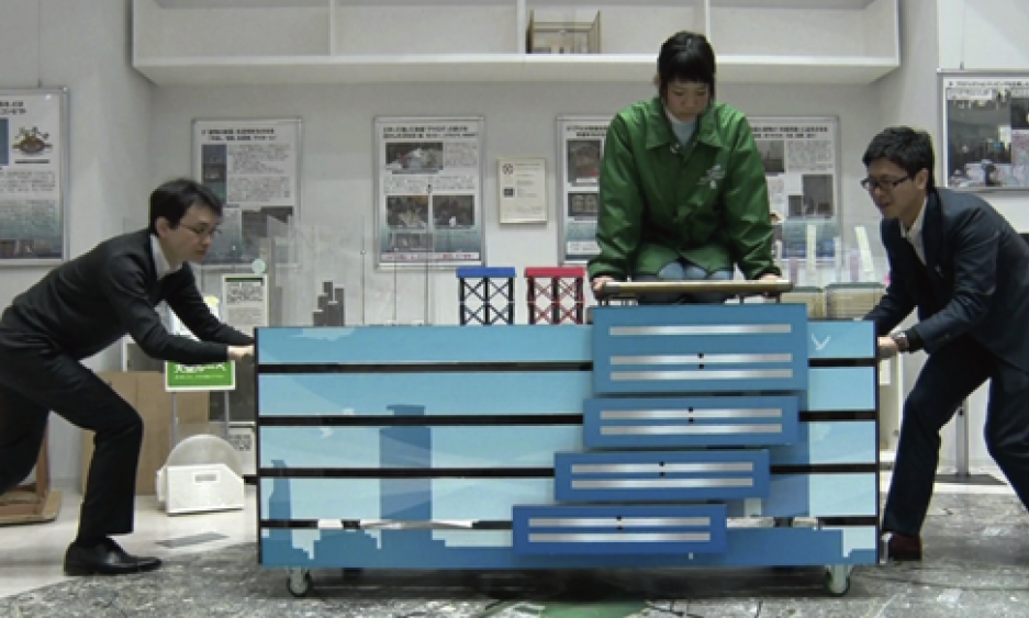
| "Koso Bururu" | Projection mapping (elevation) onto an aerial photograph of Nagoya city |
|---|---|
 |
 |
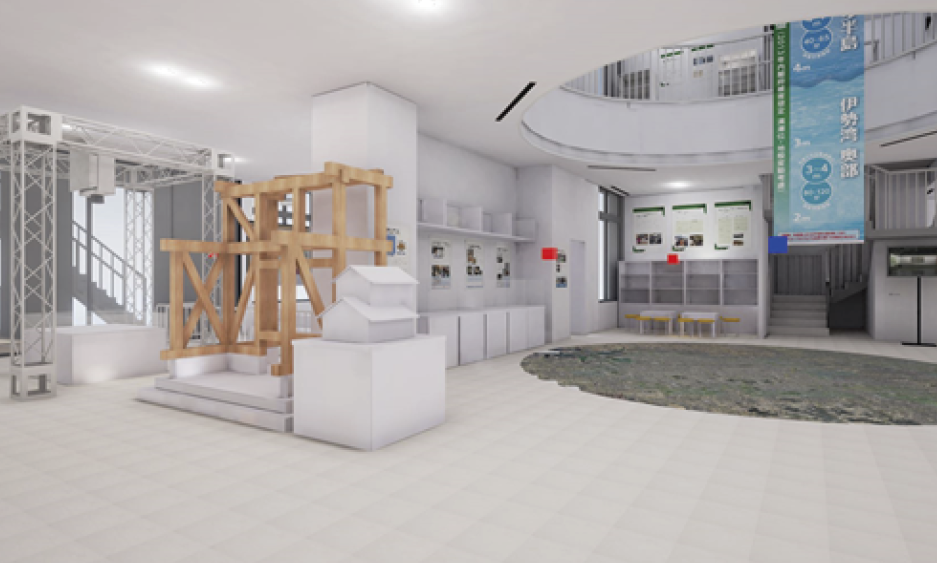
| 3-D image of the Disaster Mitigation Research Building BIM |
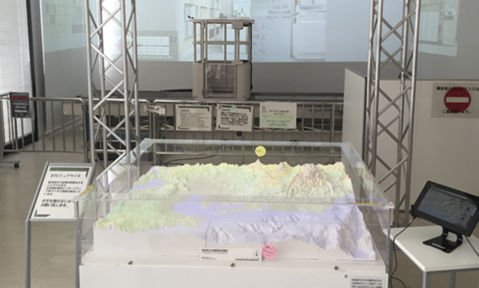
2-dimensional long stroke shaking table, "BiCURI" and a 3-D visualization |
We are developing educational materials that allow people to experience realistic sensations of an earthquake, along with materials for learning about the results of seismic engineering research. The "Koso Bururu" (High-rise Building Shaking Earthquake Simulator) is a 4-layer construction with liner guide rails. It is a large-scale educational tool that allows users to easily experience the difference in shaking according to height of the building they are in, by locking and unlocking the joints between the layers. "Bururu Glasses" combine a head mounted display and 3-D virtual room images to create a virtual reality that realistically simulates the damage caused by a massive earthquake. We also developed equipment to overlay various spatial information onto the high-definition aerial photographs of Nagoya city, using projection mapping from the ceiling. This allows visitors to visually understand the features of the terrain around their home and workplace, and how they are connected to disaster risks.
The Disaster Mitigation Research Building BIM, makes use of BIM (Building Information Modeling) construction technology, in a system that allows visitors to visualize the building as a 3-D model, from its structure right through to the interior and exhibits. It gives visitors a virtual view of things that are normally out of sight, such as the Disaster Mitigation Research Building's seismic laboratory equipment.
Development of the "Bururu" series of experiential educational tools for learning about disaster mitigation is ongoing. We have developed the BiCURI (Bi-directional shaker and Computed Ultra-Response Integration environment). The BiCURI system can simulate the "shaking of a skyscraper" using a vibrating table that reproduces the floor responses that result from an earthquake (long period ground motions,) together with videos of damaged rooms synchronized with its movements. The rooftop laboratory is able to shake the entire room at any given waveform, using an actuator. The vibration of the laboratory is synchronized with video and audio so that visitors can experience the shaking of a building caused by an earthquake through all of their senses. For detailed terrain models, 3-D visualization equipment which projects hazard maps, etc. with image enhancement based on altitude data, enables visitors to gain awareness of disaster risks based on 3-dimensional information.
In addition, we are also progressing with development of effective materials that raise awareness about disaster risks, in convenient formats. We are also developing educational materials aimed at raising awareness. These include, cards, called "MAGIC Bururu" that change design according to viewing angle (lenticular printing), making it easy to see overlays of ground conditions and hazard maps. There are also the booklets, The Story of The Sujikai Family, and The Story of The Takai Family, which combine scenarios of what might happen to regular families in the event of a disaster with information on disaster management. There is an accompanying web application based on the same content called "escape" which allows users to experience disaster scenarios.
Return to the top of the page